
Some parts of Wales have had snow recently but others have had just rain or sleet, and snow can be hard to predict!
Snow, sleet or rain? Whether it comes in autumn, winter or spring, snow is always difficult to pinpoint as BBC Weather's Louise Lear explains.

Blaenavon in the snow by Steve Liptrot Photography
Over the next few days, it’s going to stay on the cold side with high pressure bringing dry, more settled weather midweek. There should be some blue sky and sunshine on Tuesday and Wednesday with widespread frosts and icy patches, freezing fog is possible in places as well.
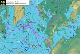
Met Office Weather chart for Wednesday 20 January
On Thursday mist and fog patches will slowly lift leaving a cloudier day but mostly dry with a little sunshine in the north.
Friday will bring a change, the high pressure will move away and it will turn milder and windier with some rain clearing to showers.

Snowy sunrise over Cribyn by Alyn Wallace
So the current cold spell looks like coming to an end later this week; temperatures on Friday reaching 9 to 12°C with south to south-westerly winds bringing milder air in from the Atlantic.
Further ahead, temperatures are expected to remain close to average for the rest of the month and into the start of February.