
It sure feels like a sauna in the weather office today! It’s hard to think I had a hot water bottle in bed at the beginning of the week and now I’m roasting. The warm and sticky conditions will continue well into the weekend. It’s all down to the warm and humid air coming up from mainland Europe.
Normally I bring the news of wet weather with the promise of something drier but according to the latest forecast not much chance of that this weekend. If anything by Sunday we’re looking at heavy downpours with the potential for a severe weather warning. So do keep an eye on the forecast throughout the weekend.
The pressure chart for Sunday shows a deep area of low pressure not too far away from Wales. This is producing a series of fronts and troughs and we all know what that means.
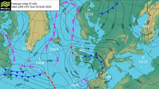
Met Office Pressure Chart for Sunday 23 August
Looking at this chart you can see why the weekend weather is looking so mixed. Saturday will start off mild with more cloud and rain spreading westwards. The rain will ease for a time with limited brightness through the afternoon. By the time we get to the evening a line of heavy showers will spread in from the south east with some of these showers possibly heavy and thundery.
Then we're into Sunday which looks pretty messy too! Just have a look at this scene and see if you can find the map underneath all that blue. Looks like the perfect day for indoor activities.
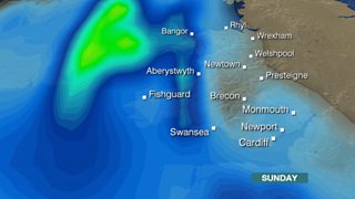
Plenty of rain forecast across Wales this Sunday
But let’s not forget that last weekend was pretty decent and I’m sure there will be more fine weather before autumn kicks in.

Red Sky at night at Pentlepoir by Jeffrey Crook