
It was a case of dodging the showers at the National Eisteddfod in Meifod last week. Thankfully though there were some drier and brighter spells. The festival finished off on a fine, sunny and very warm note on Saturday with temperatures rising into the low 20s. Meifod lies in a valley surrounded by hills and has its own microclimate; most of the rain tends to fall on the Cambrian Mountains to the west.
There were some interesting wave-like clouds over Carmarthen Bay on Monday morning. Nigel Faithfull took this picture from Saundersfoot. These are Kelvin-Helmholtz clouds and are one of the most striking and rare cloud types. They occur when there’s a strong vertical shear between two air streams causing winds to blow faster at the upper level than at the lower levels.
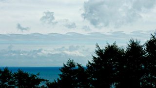
Some interesting wave-like clouds over Carmarthen Bay captured by Nigel Faithfull
So Monday has seen an improvement in the weather with heavy rain and showers replaced by dry and sunnier weather spreading from the west this afternoon. Monday evening will be fine and it will stay dry overnight with a few clouds and clear skies. It’ll be a cooler night, especially in rural areas with one or two mist or fog patches forming during the early hours. We can expect lowest temperatures of 8°C to 10°C inland and 11°C to 13°C on the coast.
On Tuesday most of Wales will be dry with sunny spells although one or two light showers are possible in the north. The best of the sunshine is likely in the south and west and on the coast with clouds building-up inland. Top temperatures will reach 19°C to 21°C in mid, south and southeast Wales and it will feel warm with light winds. Parts of the north and west will be slighter cooler with highs nearer 17°C or 18°C.
Tuesday night will be fine and dry. The cloud that builds up during the day will disperse once the sun goes down. Wednesday promises to be a fine summer's day with sunny spells thanks to high pressure and it will turn out warmer too with temperatures rising into the low 20s.
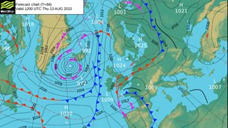
Met Office Pressure Chart for Thursday 13 August 2015
However, it’s unlikely to remain dry all week. Low pressure over the Bay of Biscay looks set to move northwards on Thursday bringing showers or longer spells of heavy or torrential rain with a risk of thunder. There’s also some very high and potentially disruptive rainfall possible!
To space now and it's that time of year again when there's a chance of seeing the Perseid Meteor Shower over the next few nights. Unfortunately you will have to stay up late or get up early to see them! The best time to see the shooting stars is after midnight in the northeastern sky.
Derek