
Pembrokeshire was the best place for sunshine today with a high of 15 Celsius in Milford Haven
Elizabeth sent us this shot of Tenby via Twitter -

'Sunny and warm in Tenby this afternoon'. Picture courtesy Elizabeth Red
Away from the south west it’s been cloudy today with rain over England spreading into south-east, mid and north Wales during the afternoon.
This evening rain in the northeast will clear but elsewhere any showers will die away. It will be dry for a time but a band of rain will then spread north across the country after midnight and the wind will strengthen.
The reason for the wind and rain is an area of deep low pressure centred over the Celtic Sea tomorrow.
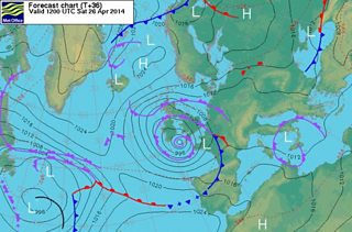
Forecast chart 25 April 2014
Tomorrow any rain in the north will clear, leaving dry and bright weather and sunny spells. However, showers are likely and these will become more widespread during the afternoon.
Most of the showers will be in the south where some will be heavy. The north will be drier and will get the best of the sunshine. Top temperatures will be 12 to 15 °C and breezy; the south to south-easterly wind strong on exposed parts of the Bristol Channel coast, Gower and the Pembrokeshire coast with gusts over 40mph.
On Sunday there will be further scattered showers, heavy in places with a risk of thunder but some dry and brighter spells are likely too. The north coast may stay dry with some sunshine and temperatures between 12 to 15 °C on Sunday afternoon with a moderate north-easterly breeze.
Next week will bring a mixture of sunshine, a little rain and showers and for the start of May the signs are that it will turn colder with Arctic winds bringing a drop in temperature and even a risk of frost.